


![]()
<!–
–>

/ecosystems/article/44988?utm_source=feedburnerutm_medium=feedutm_campaign=Feed%3A+SustainableEcosystemsAndCommunityNews-Enn+%28Sustainable+Ecosystems+and+Community+News+-+ENN%29
An update
to one of the most comprehensive maps of the Amazon basin shows that
forest cover across the world’s largest rainforest declined by about six
percent between 2000 and 2010. But the map also reveals hopeful signs
that recognition of protected areas and native lands across the eight
countries and one department that make up the Amazon is improving, with
conservation and indigenous territories now covering nearly half of its
land mass.
ADVERTISEMENT

The map was produced by RAISG, a joint effort between 11 member country organizations: the Amazon Conservation Team Suriname, DEAL-French Guiana (Guyane Française), EcoCiencia (Ecuador), Friends of Nature Foundation (Bolivia), Gaia Amazonas Foundation (Colombia), IBC (Peru), ICV — Centre of Life Institute (Brazil), Imazon (Brazil), ISA — Instituto Socioambiental (Brazil), IVIC (Venezuela), and Provita (Venezuela). The project, which is funded by the Avina Foundation, the Ford Foundation, Rainforest Foundation Norway, and the Skoll Foundation, aims to integrate and coordinate efforts to establish protected areas and indigenous reservation, overcoming “the fragmented visions commonly held of the Amazon”.
Article continues at Amazon Forest.
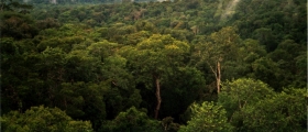
Jungle image via Wikipedia.
Terms of Use | Privacy Policy
2012©. Copyright Environmental News Network